 Skip to content

Utility Locating: Integrating Detection Technology and Tracer Wire Systems
The United States loses over $30 billion each year due to utility strikes. Smart utility locating helps prevent these incidents and keeps both people and vital infrastructure safe. Recent breakthroughs have made underground utility detection more accurate than ever.
The field of utility line locating has improved tremendously. Modern systems combine electromagnetic technology with smart tracer wire setups that boost accuracy. Our teams use everything from simple electromagnetic locators to cutting-edge ground penetrating radar devices. These tools work together to deliver complete underground utility mapping, even in tough spots. In this piece, we’ll explore how these technologies work together, the problems they solve, and the standards that guide their proper use.
Core Detection Technologies for Underground Utility Locating
Effective utility locating requires specialized detection equipment to locate different types of underground infrastructure. The foundations of accurate subsurface utility detection rest on three main technologies. Each one has its own unique capabilities and uses.
Electromagnetic Locators: Direct Connection vs Induction
Electromagnetic (EM) locators are the go-to method for detecting conductive utilities. These systems rely on two primary components: a transmitter that sends electromagnetic frequencies into the ground and a receiver that detects the electromagnetic field around the target utility.
Technicians use three primary methods to apply EM locator signals:
- Direct Connection provides the best results through metal-to-metal contact with the utility. The transmitter’s red lead connects directly to the target line, while the black lead is attached to a ground stake. Cleaning off rust or paint is essential to ensure conductivity, and this method offers control over the signal, improving accuracy.
- Ring Clamp Induction works when direct contact isn’t possible. An inductive clamp is placed around a metallic pipe or cable, allowing the transmitter’s signal to be induced onto the target line. This method is commonly used when working with telecom or cable lines, as it doesn’t interrupt service.
- Induction is used when there’s no access to the utility. The transmitter is placed on the ground above where the utility is suspected to run, emitting a signal that interacts with nearby conductive materials. This method can lead to signal bleed, making it harder to isolate a specific utility.
Ground Penetrating Radar (GPR) for Non-Conductive Utilities
Ground Penetrating Radar (GPR) works alongside EM locators and is especially effective for non-conductive utilities. GPR sends high-frequency radio waves into the ground and analyzes the reflected signals to identify underground structures.
GPR is useful for locating:
- Plastic pipes
- Terra cotta lines
- Other non-metallic utilities that EM locators can’t detect
It does not require direct contact with the ground, reducing the risk of damaging utilities. Its effectiveness is influenced by soil conditions—sandy soils work best, while dense clay soils can hinder results. New GPR systems offer advanced features, such as improved depth detection and enhanced visualization of underground structures, enabling even greater accuracy.
Acoustic Pipe Locators for PVC and Clay Pipes
Acoustic pipe locating is used to detect non-metallic pipes such as PVC and terracotta. This method involves sending sound waves through pipes, which are then detected by ground microphones, allowing precise location of underground piping systems.
Acoustic pipe locators are particularly effective for locating:
- PVC pipes
- Clay pipes
- Concrete or other non-metallic lines
Using an acoustic pipe locator helps identify these utilities without needing direct access to the pipe. This method is especially beneficial when working with older systems or in environments where direct electromagnetic induction isn’t possible.
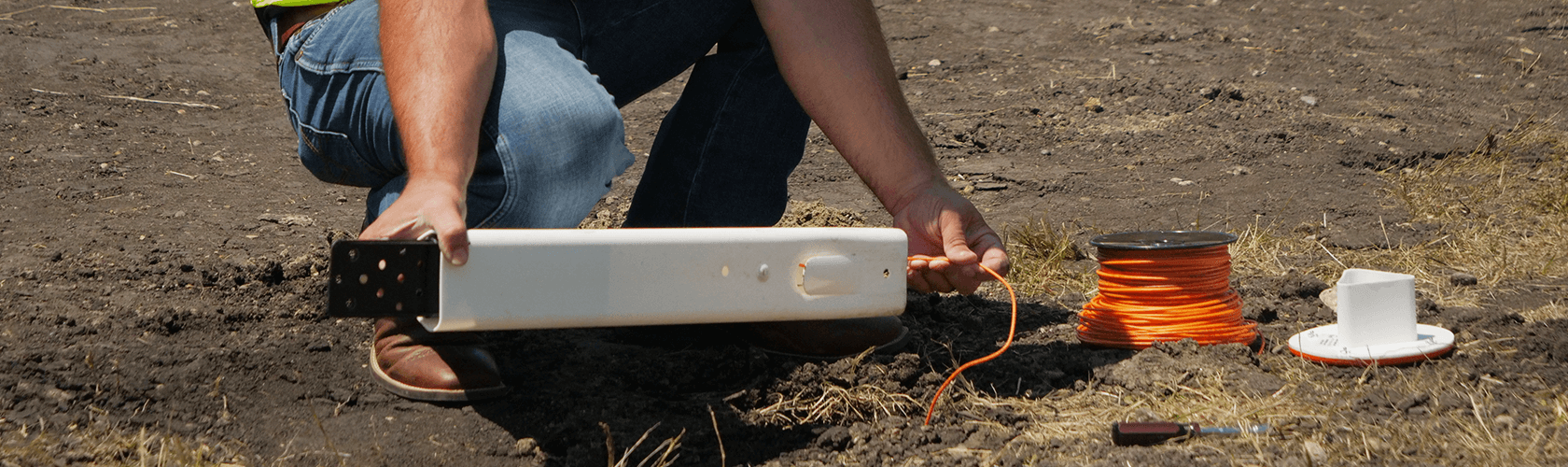
How Tracer Wire Systems Enhance EM Locating
Electromagnetic locators rely on strong, clear signals, and tracer wire systems play a crucial role in enhancing this capability. When installed properly, tracer wire systems provide clearer signals and extend the effective range of EM locators.
Pro-Trace® Copper-Clad Steel Tracer Wires for Peak Performance
Our Pro-Trace® Copper-Clad Steel (CCS) tracer wires are engineered to deliver more reliable utility locates. Unlike traditional copper wires, which are susceptible to corrosion and damage, Pro-Trace® CCS wires are composed of a carbon steel core with copper metallurgically bonded through heat and applied pressure. This design offers several advantages:
- Equal signal strength compare to copper and clarity over long distances
- Increased durability to withstand environmental stresses
- Resistance to corrosion, ensuring long-lasting performance
These wires are specifically designed for demanding utility locate applications, providing a stronger and more dependable signal even in tough conditions. Crews can rely on these high-performance wires to help ensure accurate and reliable utility identification. Our CCS Tracer Wires include: Pro-Trace HDD-CCS PE45/PE50, Pro-Trace HF-CCS PE30/PE45, Pro-Trace HS-CCS PE30/PE45
Pro-Trace® Connectors for Reliable Connections
Connecting tracer wire segments reliably is essential for maintaining signal consistency and quality. Pro-Trace® Connectors are engineered to ensure strong conductivity across wire segments, providing:
- Corrosion resistance for long-term reliability
- Moisture-resistant designs to prevent signal loss in wet conditions
- Efficient, simple installation for quick setups
These connectors ensure that signals remain clear and uninterrupted, enhancing the effectiveness of your utility locating efforts.
Test Stations, Terminal Posts, and ISO Switches for Field Efficiency
Test stations, terminal posts, and ISO switches play a crucial role in improving the efficiency of utility locating. These components provide accessible and reliable connection points for tracing utilities in the field.
Test Stations and Terminal Posts for Easy Access
Our test stations feature weather-resistant enclosures and are color-coded to meet industry standards, ensuring utility markings are clear and easily identifiable in the field. These test stations make it easier for technicians to establish connection points without needing to dig up utility lines.
Terminal posts are integral to providing a grounded connection point for the tracer wire system. They help improve signal strength and reliability by providing an easy way to tap into the wire for accurate locating, while also protecting the integrity of the underground systems.
ISO Switches for Isolating Specific Utility Segments
Our ISO switches are incorporated directly into test stations to enhance functionality. ISO switches allow technicians to isolate specific segments of a utility network, ensuring more accurate results during a locate. Key benefits include:
- Precise isolation of utility segments, preventing interference from nearby lines
- Simplified troubleshooting, as technicians can focus on individual sections without affecting the entire system
- Reduced signal bleed, which is especially helpful in dense utility networks
By isolating specific portions of a utility line, ISO switches help improve accuracy and speed up the locating process, making it more efficient for both the technician and the overall project.
Signal Interpretation and Depth Estimation Techniques
After detecting a utility, it’s important to interpret the signals correctly in order to determine the exact location and depth of the utility. Technicians must be skilled in interpreting the different modes of electromagnetic locators and applying depth estimation techniques.
Peak vs Null Mode Accuracy
Electromagnetic locators use two operating modes to help pinpoint utility locations:
- Peak Mode: Displays the maximum signal strength when positioned directly above the utility. It is the most accurate for determining the centerline position, although it can be affected by multiple utilities in the area.
- Null Mode: Displays the weakest signal when directly over the utility, with the signal strength increasing as the receiver moves to either side. Null mode provides quick left/right guidance and helps technicians identify the utility’s actual location.
Technicians often use both modes in combination to confirm their findings, ensuring accurate locates.
Triangulation and Elevation Change Methods
To increase accuracy, technicians may employ triangulation or elevation change methods:
- Triangulation: Technicians move the locator to a 45-degree angle from the peak signal and adjust until they receive an equal signal strength from both sides. The point where these readings intersect marks the utility’s true location.
- Elevation Change: By raising the receiver vertically, technicians can test the consistency of the signal. A stable reading suggests a clean locate, while fluctuations may indicate interference or the need for further investigation.
Digital Depth Estimation
Modern utility locating equipment often includes digital depth estimation features, which provide depth accuracy within +3-5% of actual depth under optimal conditions. This technology allows for better excavation planning and helps prevent costly mistakes during the digging process.
Challenges in High-Interference and Urban Environments
Utility locating in urban areas presents unique challenges. High levels of electromagnetic interference from various sources can complicate the detection process, requiring skilled technicians to adjust frequencies and use specific techniques to ensure accurate results.
Active Interference from Other Systems
Cable television lines, dog fences, and cathodic protected gas mains all generate electromagnetic signals that can interfere with utility locating efforts. Skilled technicians use frequency adjustment techniques to avoid interference and ensure a clean signal for the target utility.
Passive Interference from Metal Objects
Metal objects such as rebar, chain-link fences, and storm culverts can absorb or deflect electromagnetic signals, leading to signal distortion. Technicians may need to adjust their antenna settings or use different angles to minimize interference.
Standardization and Documentation in Utility Locating
Standardization is key to ensuring reliable utility locating practices and protecting against accidental utility strikes during excavation.
APWA Color Code System for Utility Marking
The APWA color code system is the industry standard for marking utility lines. It provides a universally recognized color scheme that helps prevent confusion when locating utilities, ensuring safe and efficient excavation practices.
GIS Integration with GPS-Enabled Locators
Integrating utility locating systems with Geographic Information Systems (GIS) enhances the accuracy of underground utility mapping. GPS-enabled locators capture precise facility coordinates, creating detailed maps that professionals can use for reference in future projects.
Conclusion
This piece explores how modern utility locating has evolved into a sophisticated field that combines multiple detection technologies with purpose-built tracer wire systems. A mix of electromagnetic locators, ground penetrating radar, and acoustic pipe locators now work together to form a detailed approach to finding underground utilities. These technologies, when combined properly, cut down the $30 billion yearly cost of utility strikes in the United States significantly.
By employing the right tools, like Pro-Trace® CCS tracer wires, ISO switches, and efficient test stations, teams can achieve impressive accuracy with depth estimates and minimize costly infrastructure damage. Skilled technicians adapt to challenging environments, overcoming interference from active and passive sources, and utilizing advanced signal interpretation techniques to ensure safe and accurate excavation.
Standardized practices and clear documentation, such as the APWA color code system and GIS integration, are crucial in protecting utilities and facilitating better communication between all stakeholders involved. With improved technology and proper protocols, the utility locating industry is positioned to reduce costly errors and enhance safety moving forward.